Texas State Parks
A Number Of The Texas State Parks Are Located On The Famous Rio Grande River
There are seventy nine state parks in Texas which is the largest state in America after Alaska. It is known as the "Lone Star State" as a reminder that it was an independent republic from 1836 until 1845 when it joined the Union as the 28th state.
|
To See A List Of Texas State Parks Just Click Here |
Texas has long been associated with the image of the stetson wearing cowboy in his dusty boots. This is because of the cattle industry that thrived for many years after the American Civil War. Nowadays when people talk about Texas it is usually the oil industry that comes to mind. |

"The Lighthouse" Rock Formation In Palo Duro Canyon, Second Largest Canyon In America
Covering almost 270,000 square miles of land, Texas is a little larger than France and twice as large as Japan. It is located in the south central part of the United States and has an extremely diverse landscape.
There are coastal swamps, plains, hills, woods, deserts, huge sand dunes and mountains. Texas is also home to Palo Duro Canyon, the second largest canyon in America.
All of these different landscapes feature in the Texas State Parks as well as the long coastline on the Gulf of Mexico. A number of the state parks in Texas are located on the coast and the barrier islands just offshore.
The coastal parks include Boca Chica State Park, Goose Island State Park and Sea Rim State Park while Matagorda State Park and Galveston Island State Park are found on barrier islands.

Rio Grande River Running Through Santa Elena Canyon In The Big Bend National Park
Texas is home to fifteen major rivers the most notable of which is the Rio Grande. Naturally a number of Texas State Parks are located on this famous river, they include Big Bend Ranch State Park which covers a massive 269,714 acres of land and is the largest of the state parks in Texas.
The Rio Grande forms the international border with Mexico to the south west of the state and there are two other rivers that help to define the state of Texas.
The Sabine River, running from north to south, forms the state line between Texas and Louisiana its neighbor to the east while The Red River separates Texas from Oklahoma and Arkansas to the north.
Although the state has many rivers and streams it has very few natural lakes. Caddo Lake State Park, in eastern Texas, is found on the famous Caddo Lake which was formed hundreds of years ago by a huge log jam known as "The Great Raft."

Caddo Lake In Texas
Despite so few natural lakes there are over one hundred man-made reservoirs in Texas and many of the Texas State Parks are found located on their shores.
They include Lake Arrowhead State Park, Lake Brownwood State Park, Lake Corpus Christi State Park, Lake Livingston State Park and Lake Tawakoni State Park.
Many outsiders probably envision Texas as a flat desert-like place. In fact less than ten percent of the state is desert. Big Bend Ranch State Park, close to the Rio Grande River, does have areas that have a desert ecosystem.
However, even Monahans Sandhills State Park with its huge seventy feet high sand dunes is not actually desert land as it has groundwater and an annual rainfall of over twelve inches.

The Franklin Mountains In Texas
Two of the state parks in Texas prove that the land isn`t all flat. Davis Mountains State Park is in an area over 5,000 feet above sea level as is Franklin Mountains State Park in El Paso.
It is obvious that in an area as vast as Texas that there will be numerous different landscapes and ecosystems. The Texas State Parks cover every one of them. This variety of scenery, together with their first class facilities, provides wonderful leisure opportunities for the millions who visit every year.
Here is a list of the Texas State Parks
|
|
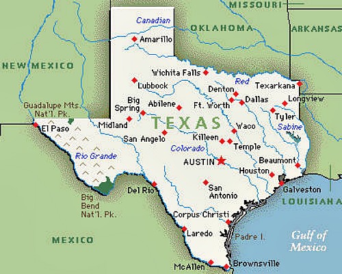
Here is a map of the state of Texas


